Farm dams are common throughout the Gilbert catchment and GRAP for stock and domestic use. High evaporation and high infiltration in many areas mean that losses are high. They do, however, help support water availability.
Data about farm dams
Farm dams are a type of water body. Large water bodies in the region have been mapped, and with remote sensing, information is available on their area over time. Digital elevation models (DEM) can provide information about the capacity of farm dams based on area and depth.
Existing dam capacity across the GRAP is estimated to be at least 10GL, that is, at least half of the entire capacity of the bed sands, and twice the volume of bed sands entitlements. Current policy readily enables the building of small on-farm dams (< 250 ML) as such dams are self-assessable works that do not require a water license.
Gully dams especially would be expected to capture runoff (as well as sediment from erosion). Seepage and flows from water bodies may help top up soil water and groundwater. Construction of many small dams that take overland flow before it can reach watercourses could have a localised impact on waterhole formation and their persistence over a year. It is expected that water levels in specific bed sands pools and waterholes of the GRAP could be sensitive to capture of late season runoff or associated changes in flow patterns.
Smaller water bodies are typically implicitly included in catchment scale runoff modelling - they show up through their effect on timing of streamflow after rainfall. Larger water bodies can be explicitly modelled.
Water budgets for the catchment of a water body can provide a first estimate of its water balance over time. It is possible to estimate capacity relative to inflows (from area and depth) or in terms of time for dam to fill or empty. This allows exploration of the amount of water that will actually be in the dam, accounting for extraction, evaporation, and other losses. Water policy restricting capture and use of the water also needs to be taken into account.
Planning farm dams
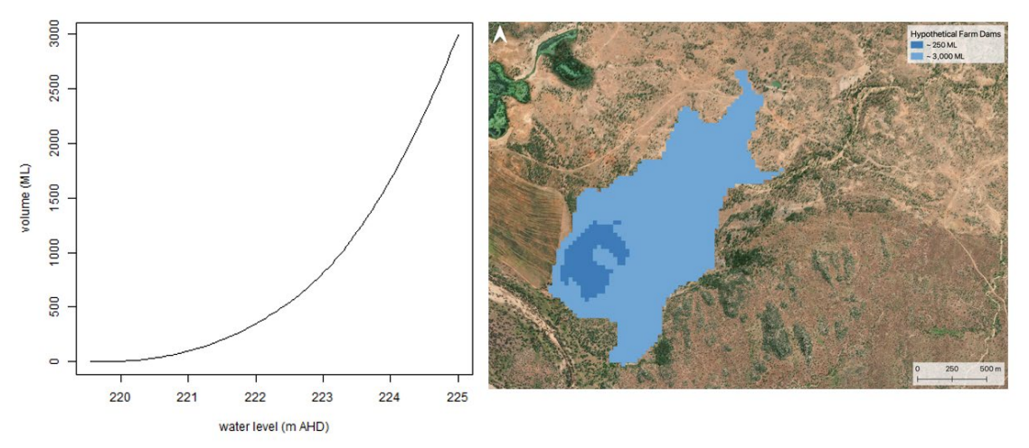
A preliminary assessment of possible sites for dam walls can be made using digital elevation models (DEM) by assessing the area, depth and capacity of the area that would be flooded. The area flooded can be mapped on top of aerial imagery, and an indicative volume calculated for different dam heights. In the example provided here, the smaller dam is ~250 ML, the volume and area of the larger dam will depend on the height of the water level and dam wall. A ~6m high dam wall could hold up to ~3000 ML.
Smaller farm dams for stock and domestic use are possible without the need for water licences, however, development approvals could be required. In the GRAP, sites potentially suitable for farm dams are often not cleared and are of vegetation classifications less likely to receive approval for clearing. Farm dams capturing overland flows often cross streams and therefore involve “waterway barrier works”.
There are existing large farm dams and an old mining dam within the GRAP that are currently used only for stock use but which could be useful for irrigation (e.g. crop finishing). In theory, these water sources could be used to refill the bed sands to minimise evaporative losses and support smaller-scale delivery of irrigation within the GRAP. Minor dams located on secondary tributaries may be preferable to some local stakeholders than large instream dams on the Gilbert River 1.
Resources
On this website: